
ISRO Satellite Images Unveil Concerning Expansion of Himalayan Glacial Lake.
ISRO's satellite images reveal alarming growth of Himalayan glacial lakes, posing GLOF risks. Climate change, satellite monitoring, lake expansion.
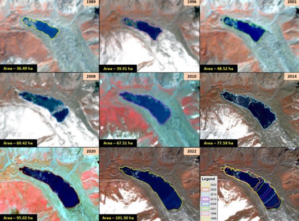
The most recent satellite imagery released by the Indian Space Research Organisation (ISRO) has sparked global concern, revealing a significant expansion of glacial lakes in the Himalayas over the past three to four decades. According to ISRO's findings, more than 600 lakes, constituting 89% of the total glacial lakes in the Himalayas, have doubled in size during the past 30 to 40 years. Notably, the Ghepang Ghat glacial lake in the Indus River Basin, situated at an elevation of 4,068 meters in Himachal Pradesh, India, has witnessed a staggering 178% growth, increasing from 36.49 to 101.30 hectares between 1989 and 2022, with an average annual increase of 1.96 hectares.
Long-term satellite observations spanning from 1984 to 2023 across the Indian Himalayan river basins have documented significant changes in glacial lakes. Among the 2,431 lakes larger than 10 hectares identified during 2016-17, 676 glacial lakes have notably expanded since 1984. Specifically, within India, 130 of these lakes are found, with 65, 7, and 58 lakes situated in the Indus, Ganga, and Brahmaputra River basins, respectively.
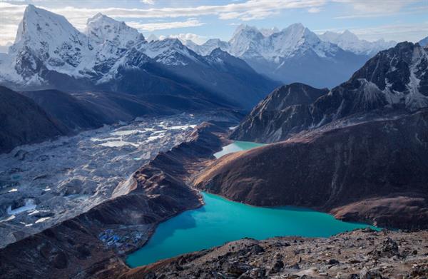
The Himalayan Mountains often termed the Third Pole due to their vast glaciers and snow cover, are highly susceptible to global climate changes, which impact both their physical characteristics and societal consequences. Research globally consistently indicates that glaciers worldwide have been retreating and thinning at unprecedented rates since the Industrial Revolution, resulting in the formation of new lakes and the enlargement of existing ones in the Himalayan region. These glacial lakes, formed by melting glaciers, serve as vital freshwater sources for Himalayan rivers but also pose significant risks, including Glacial Lake Outburst Floods (GLOFs), with potentially devastating consequences for downstream communities.
ISRO emphasized that GLOFs can occur due to various triggers such as avalanches, extreme weather events, and environmental factors, leading to the sudden release of large volumes of meltwater from glacial lakes, often due to the failure of natural dams made of moraine or ice.
Monitoring and studying glacial lake occurrence and expansion in the Himalayan region are challenging due to the rugged and inaccessible terrain. However, satellite remote sensing technology proves invaluable for inventory and monitoring due to its wide coverage and revisit capability.
The elevation-based analysis revealed that 314 lakes are located in the 4,000 to 5,000-meter range, while 296 lakes are situated above 5,000 meters elevation. Glacial lakes are categorized into four main types based on their formation process: Moraine-dammed, Ice-dammed, Erosion, and other glacial lakes. Among the 676 expanding lakes, the majority are Moraine-dammed (307), followed by Erosion (265), other (96), and Ice-dammed (8) glacial lakes.
The ISRO emphasized that satellite-derived long-term change analyses provide valuable insights into glacial lake dynamics, essential for understanding environmental impacts and developing strategies for managing GLOF risks and adapting to climate change in glacial environments.
| Follow the Hindeez on Google News |  |
| Follow the Hindeez channel on WhatsApp |  |

We hate spam as much as you do
© Hindeez 2026, All Rights Reserved